A Notice to Mariners has been issued today by the Port of Liverpool advising of some areas of exposed cable in Liverpool Bay. This cable will from part of the Western HVDC Link undersea electricity cable. The full notice can be downloaded here and is summarised below.
Exposed Cable
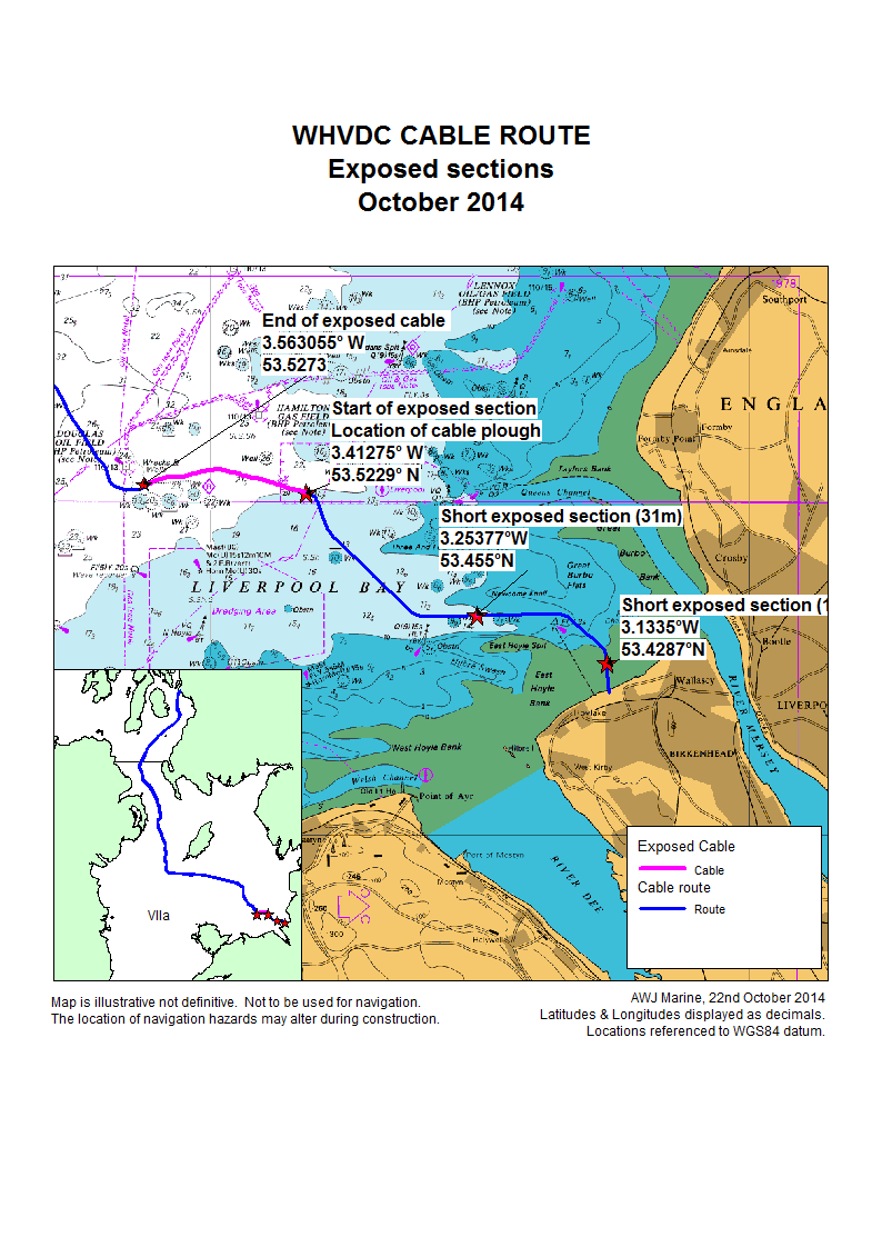
There are three lengths of exposed cable in Liverpool Bay. The locations are shown in a map that can be downloaded here. More information about each exposed section is given below.
Exposure due to weather
During the recent stormy weather, the cable laying vessel Atalanti had to temporarily lay around 10km of cable on the seabed, rather than simultaneously laying and burying the cable. This action was taken to avoid damage to the cable. The plough being used to bury the cable has also been left on the seabed. The location of the plough is marked with a buoy and being guarded by the vessel Artemis.
Now that the weather has abated, the exposed cable is being retrieved by the Atalanti. Retrieval started on the 23rd October 2014.
The exposed cable and the plough are currently being guarded by the cable laying vessel Atalanti and the support vessel Artemis. The coordinates of the exposed cable and the cable plough are:-
- Start of exposed cable and cable plough:
- 53.5229°N 03.41275°W
- End of exposed cable
- 53.52736°N 03.563055°W
Short inshore exposed section
A length of 31 metres of cable is lying exposed in Liverpool Bay. The coordinates of this length are:-
- 53.455°N 03.253303°W to
- 53.45499°N 03.25377°W
Remedial action will be taken to bury this length of cable at the earliest opportunity.
Intertidal exposed section
A length of 11 metres of cable is currently unburied on the Wirral foreshore. The coordinates of this section of cable are:-
- 53.42867°N 03.1355°W to
- 53.42867°N 03.1335°W
Again, remedial action will be taken to bury this length of cable at the earliest opportunity.
Vessel details & cable installation programme
A notice about the installation of the shallow water section of the Western Link cable can be downloaded here.
The call sign for the cable laying vessels and a link to their current location (from MarineTraffic.com) is given below:-
The vessels will monitor VHF Channel 16 at all times.
The Western HVDC Link
The Western Link will be an undersea cable linking Ardneil in the Clyde with the Wirral in north-west England. Details of the project can be found on our website here.
Cable laying schedule
Installation of the Western Link cable started in the shallow waters at the southern end of the route in October 2014. The main cable installation campaigns are due to be completed by February 2016.
Further information about the installation schedule and the vessels that will be carrying out this work will be circulated to all interested parties as construction proceeds.
If you have any queries about the Western Link project, please contact Jim Andrews, Fisheries Liaison Officer by e-mail or by phone on +44(0)7908-225865.